

Course |
Excavation |
Accommodations |
Dates & Fees |
Team |
Free Time |
Seminars |
Official web |
|
Course
This course is aimed at students and people interested in archaeology who wish to participate with us in this archaelogical course at the site of Coimbra, located 2 km South of Jumilla in Murcia (Spain), will be able to study first hand the classic Iberian town and necropolis in the Iberic period.
The Iberian village of Coimbra del Barranco Ancho in Jumilla is located at 38 ° 26’9 «North latitude and 2 ° 21’40» East longitude, according to the sheet n ° 869 «Jumilla» of Catastral Geographic Institute at 1: 50,000, to 4.5 km. South-Southeast of the town of Jumilla, in the Northern foothills of the Sierra de Santa Ana.
From Jumilla it is accessed by the county road 344 to Cieza. A little over three kilometers, turn left taking a path to Iryda service road that connects with the main road to Jumilla, leading to the monastery of Santa Ana. After only a mile you will find a narrow gauge road which turns to the right (almost a path) called «Casa del Cerro» between vineyards that finishes in an abandoned village, where there was a water source until a few years ago. This fountain is at the base of Cerro del Maestre, at the foot of the necropolis path. The sanctuary is about 150 m. to the East and the village necropolis where the main access to the village is can be found at about 300 m. to the West.
In recent years the CEPOAT has been working with this site on the development of their excavations, as one of the members of CEPOAT is the director of this dig.
The archeology course we offer is an intensive training course in fundamentals such as Strati-graphy, GIS, Photogrammetry, CAD, topography, field drawing, materials inventory, etc
The developed program is as follows:
1. Introduction to archaeology.
1. Concept, limits and meaning of archeology.
2. Archaeology and sources: written and materials.
3. Methods and techniques: the exploration, excavation and dating methods.
2. Methods and techniques of archaeological excavation.
1. The formation of the archaeological record: General deposition processes.
2. The concept of strata and training: relative dating. Terms ante quem and post quem. The concept of strati-graphic unit. Strati-graphic relationships between units. The matrix Harris.
3. The system open area excavation and its application in different situations.
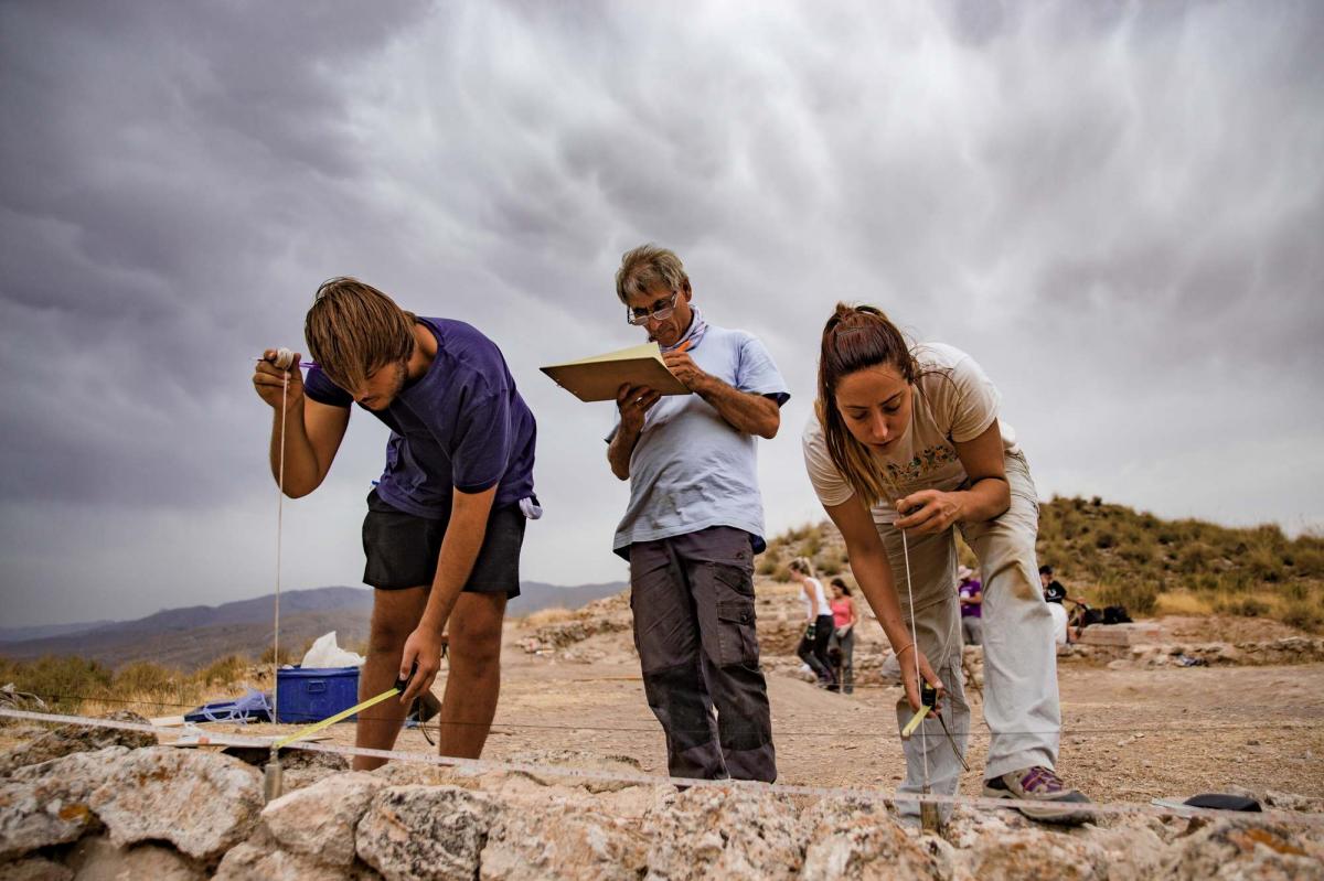
4. The data record. The daily and strati-graphic records. The field drawing and photography in the excavation.
5. The manual collection of objects. Artifacts and registration. The recovery of small remains: screening and flotation. The first preservation of the remains in the field.

3. The archaeological field drawing.
1. Introduction to archaeological field drawing: registration.
2. Main instruments and materials of archaeological field drawing.
3. Techniques for making the planimetry of the site: the perpendicular to the reference axis, triangulation, cross drawing, elevations and walls.
4. The planimetry: scale and landmarks.
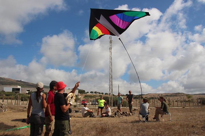
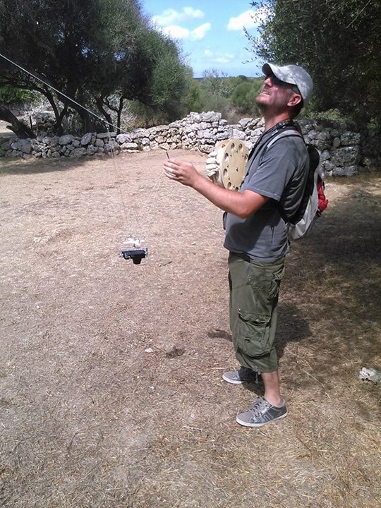
5. The use of new technologies for the drawing: photogrammetry.
6. The Kite aerial photography (KAP).

4. The layout of the site: basic principles of surveying, leveling and total station.
1. The layout of the site: basic principles.
2. Basic Principles of surveying and leveling.
3. How to install a level and take dimensions.
4. The use of the Total Station.

5. The recording of archaeological remains: materials inventory.
1.The archaeological inventory: method and phases.
2.Physical characteristics and technology of archaeological materials.
3.Physics description, use and functionality of the archaeological material.
4.The record of archaeological materials: inventory. Cleaning, sorting, and numbering (recording). Tables and databases.

6. Ceramics: Iberian and Greek pottery.
1. The Iberian pottery
2. The Greek pottery

7. The technical drawing of archaeological materials.
1. The technical drawing of archaeological materials: basic principles.
2. Materials needed for technical drawing of archaeological materials.
3. Phases technical drawing: outline, details, profile and section.
4. Scale, frame and shadow drawing artifacts.
5. The technical drawing of pottery pieces.
6. The digital drawing of archaeological materials.

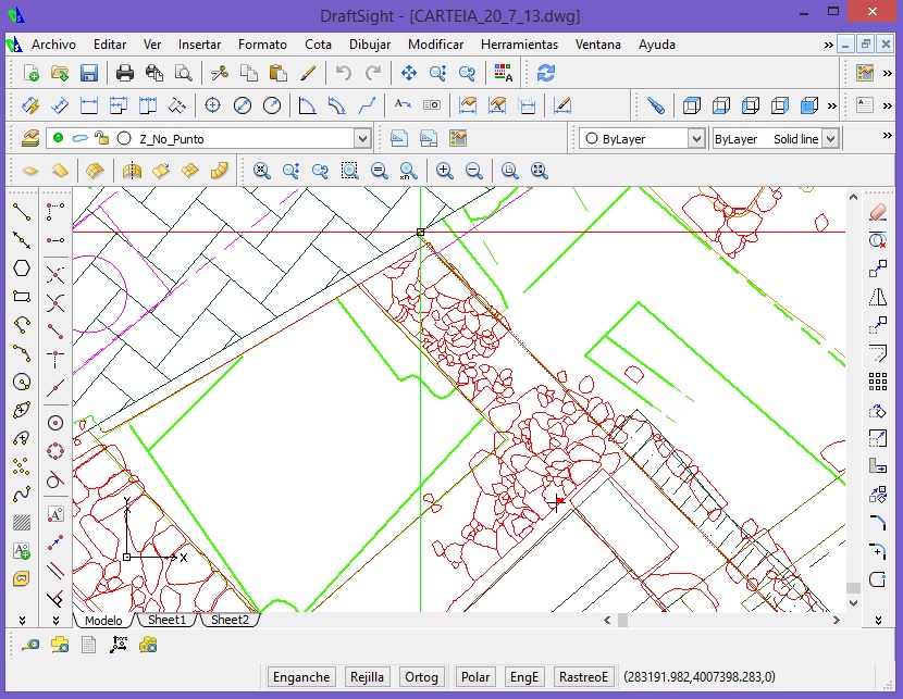
8. Computer Management of archaeological records: Draftsight, Inkscape, Gimp, Databases, etc.
1. Vector Drawing with Draftsight and Inkscape.
2. Photo retouching with Gimp.
3. Databases with Open Office.

9. SIG. Applications to the archaeology of the area.
1. Basic concepts of cartography.
2. Using QGIS.
3. Geo referencing of raster data.
4. Generation of Digital Terrain Models.
5. The interpolation of vector data.

10. Preventive conservation and restoration of sites.
1. Buried and exhumed objects. The conservation of movable and immovable property.
2.Taking care of the objects found in the intervention. The figure of the restored-conservative archaeological excavation equipment.
3. Preventive conservation of archaeological remains: bindings and coating remains.
4. The restoration of the deposits: intervention criteria. Methods and techniques.

11. Presentation of results: writing memoirs, interpretation and publications.
1. The development of the report of the archaeological excavation.
2. The presentation of the results: Final Report.
3. Content of Memory: results, performance, floor plans, records of strati-graphic units, photographic repertoire, materials inventory, etc.
4. Publication of the results: social obligation
5. How to prepare press releases, scientific articles and conferences.
The daily agenda is as follows:
Daily field activities:
The course is divided into different activities throughout the day.
The first day will be given an explanation of the site, structures and phases, and the intervention project for students to be aware at all times of what to do and previously raised an excavation.
The working system will also be divided between mornings and afternoons, in order that students will go through each and every phase of the archaeological excavation and be able to acquire the basic knowledge and methodology necessary to undertake any archaeological intervention.
Morning (8:00 to 13:30):
The students will see field theory as well as practice of the course topics 1, 2, 3 and 4.
Each morning all students will be divided into 5 groups of 5 people who will be assigned different tasks through rotations in their archaeological area group such as topographic measurements, completion of daily field drawing, taking photographs and conducting sheets Stratigraphic units.
Afternoon (17:00 to 20:00):
All students will be taught theory and laboratory practice items 5, 6, 7, 8, 9, 10 and 11.
In the afternoon the students will remain in their groups, they then will carry out archaeological laboratory work for a complete understanding of archaeology in all its facets and phases, either conducting inventory of the materials found in the excavation during the morning, drawing the most significant items found, or the computerization of data collected in the field, through databases for daily registration of materials, units and photographic registration, while vectorization of field drawings using CAD programs for integration into general planimetry. Moreover we will make emphasis on the importance of conservation and restoration of archaeological remains through restoration work in the laboratory, while also delve into how it should be presented in an archaeological memory.
Timeline:
The students will be divided into teams and within each team each student has a letter which allows you to go through all the tasks and learn the basics over two weeks.
| Morning from 8 to 14h | Monday | Tuesday | Wednesday | Thursday | Friday | Saturday |
| 8,30 a 9,30: Level | A | B | C | D | E | optional review |
| 9,30 a 10,30: Photogrammetry | B | C | D | E | A | optional review |
| 10,30 a 11 Mid Morning snack | – | – | – | – | – | |
| 11 a 12,30: Field Drawing | C | D | E | A | B | optional review |
| 12,30 a 2: Total Station | D | E | A | B | C | optional review |
| 8 a 2: Diary, Photos, Level & EU | E | A | B | C | D | optional review |
| Afternoon from 17 to 20h | ||||||
| Inventory | A | B | C | D | E | optional review |
| Photogrammetry & SIG | B | C | D | E | A | optional review |
| Ceramic drawing | C | D | E | A | B | optional review |
| Ceramic wash | D | E | A | B | C | optional review |
| Diary & EU Register on PC | E | A | B | C | D | optional review |
| Task | Morning | Task | Afternoon | ||
| 1 | Diary & EU, : Explanation and filling of field diary and tabs of Stratigraphic Units, as well as taking daily topographic measurements. | 1 | Ceramic wash: Ceramic washing process and initial classification. | ||
| 2 | Photogrammetry: Explanation of the operation and use of the photogrammetry by means of an example in field to realize by the students. | 2 | Inventory: Explanation of ceramic classification systems and inventory through databases. | ||
| 3 | Level: Explanation of use and handling of Level for the taking of topographic measurements. | 3 | Ceramic drawing & vectorization: Explanation of the ceramic drawing by hand and its vectorization using Inkscape. | ||
| 4 | Field drawing: Explanation of the traditional field drawing in the field. | 4 | Daily data Computerization: Computerization of the data collected during the excavation process in the morning. | ||
| 5 | Total Station : Management and use of Total Station for the topography of the site. | 5 | Archaematic with Draftsight (CAD), SIG (QGIS), Photogrammetry: Management of computer applications for specific use in archaeology. | ||
|
|
|
|
|
||
| Team 1 | Team 2 | Team 3 | Team 4 | Team 5 | |
| A | A | A | A | A | |
| B | B | B | B | B | |
| C | C | C | C | C | |
| D | D | D | D | D | |
| E | E | E | E | E | |
The course is developed within the concept of international course so the vehicular language will be English and Spanish have at all times of archaeologists and bilingual coordinators will explanations in English and Spanish at all times, so that he may be able to them serve to learn and improve your Spanish to be a mixed course.
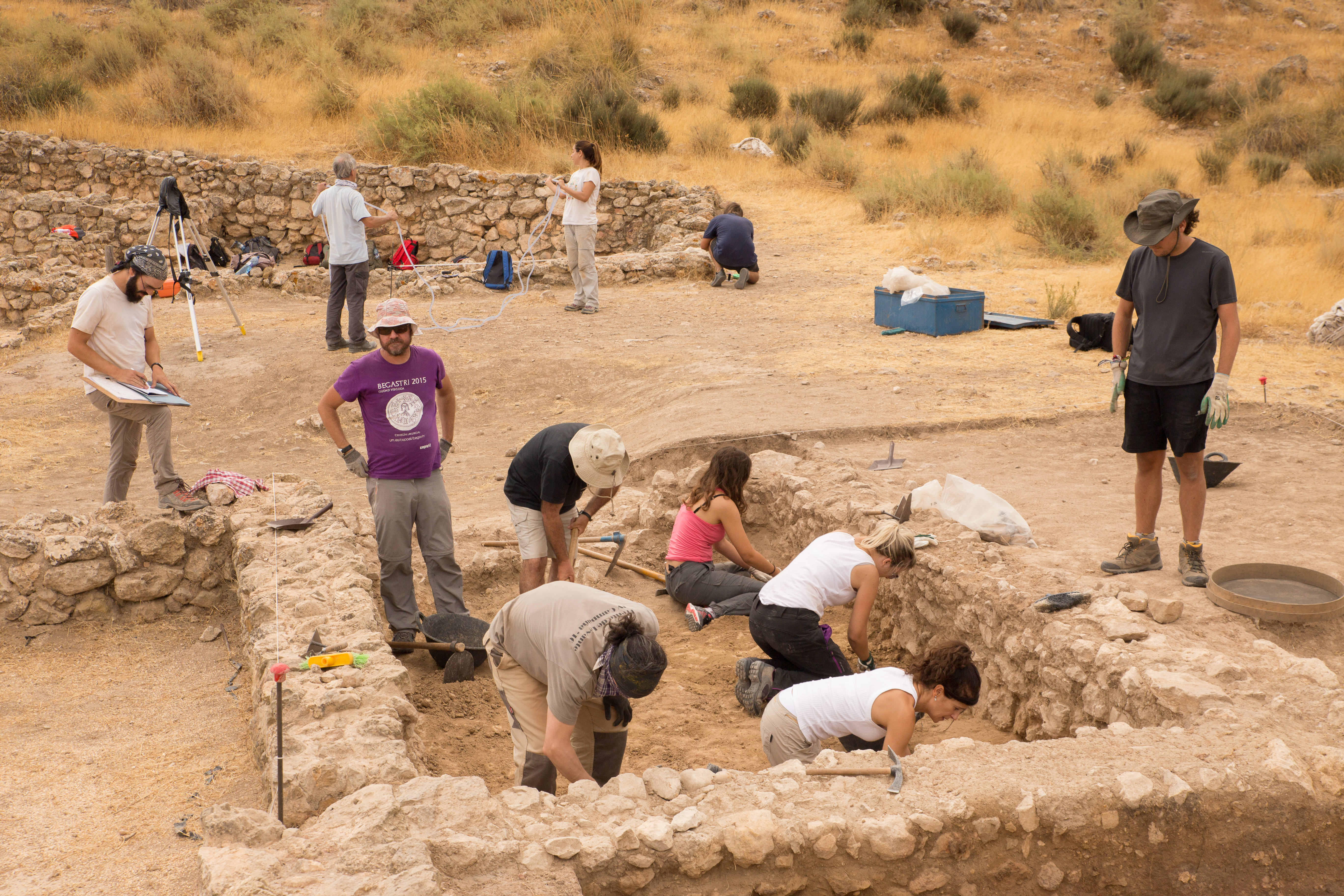
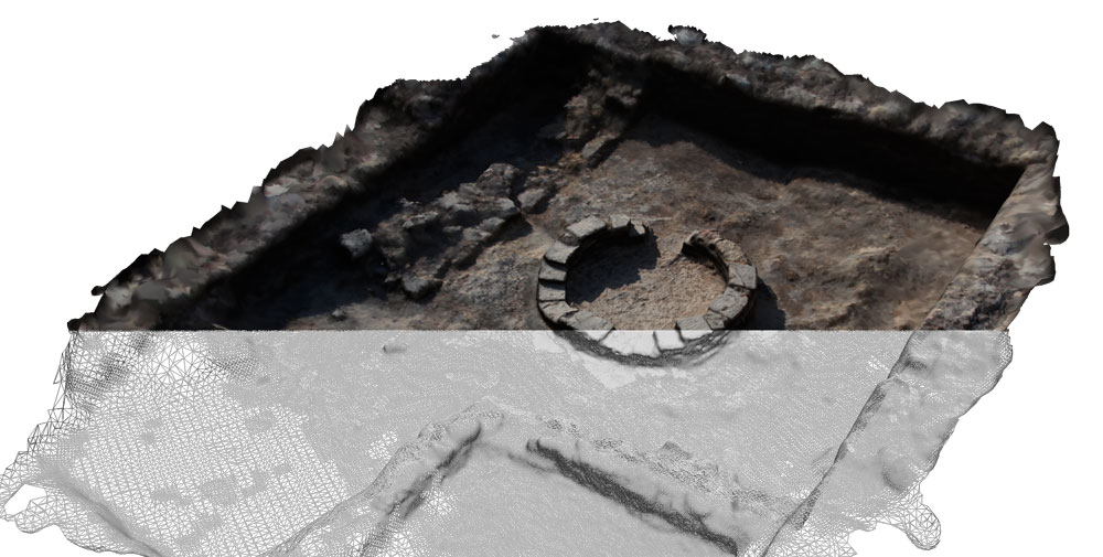
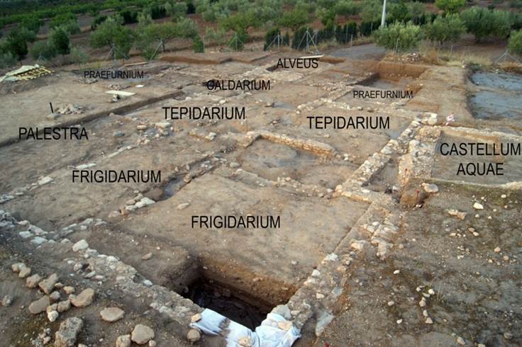
Excavation
The town
The Town of Coimbra, together with the habitat around the Cerro del Castillo (Jumilla), constitutes the two major population centers of the highlands Jumilla-Yecla.
The Village is situated on the first third of the escarpment north and southeast of Cerro del Maestre, between 700 and 825 m. above sea level in a strategic location overlooking the natural pathways that connect the Altiplano to the Valle del Segura and the continuation of this road to Mancha, through the Cerro de los Santos.
Necropolis Town
It is located in the same plain as the Town, in its Eastern segment, about 630 meters above sea level. It is about 130 meters long and about 35 wide in a North-South direction.
After the first campaigns by Jerónimo Molina between 1956 and 1960, the archaeological activities in the Necropolis of Poblado was resumed by Ana María Muñoz Amilibia steadily from 1980 until 1986. Systematic excavations were resumed and continued from 1998 until today.
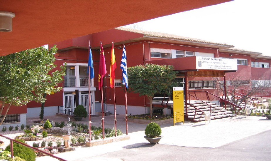
Accommodations
The students will stay in the youth hostel CECA- Centro de Capacitación Agraria.
This hostel offers group rooms, showers, toilettes and leisure spaces for young people.
Capacity: 20 people.
Breakfast, mid morning snack, lunch and dinner will be prepared by a local chef at a nearby lodge restaurant. If there are any vegetarians or anybody with any kind of allergy should inform us as soon as possibly.
How to get Jumilla:
Buses to Jumilla can be reached every hour from the bus station in Murcia.
Students should be at the youth hostel «CECA» on Sunday from 17:00 onwards.
Hostel CECA.
Location
Fees
European students: 300 €
European, not students: 500 €
Overseas, both students and not students: 800 €
Registration and Enrollment: You must pre-register by sending an e-mail to arqueologia@cdlmurcia.org and send your CV
For the completion of the course must make the payment of tuition by bank transfer to the College of Letters and Sciences of Murcia in Caixabank SWIFT (BIC): CAIXESBBXXX account ES5521008309261300018407 or Sabadell SWIFT (BIC): BSABESBB account ES7800811016110001835987 indicating the name of the course and student name.
A copy of the deposit should be sent to arqueologia@cdlmurcia.org indicating the name of the course and the name of the student in the subject line.
Fees include: accommodation and meals – Seminars – Health insurance.
Students should arrive the day before from 7:00 p.m. onwards at the hostel.
Fees do not include airfare or arrival transportation.
Cancellation and Refund Policy: Once you have registered and paid for the course unfortunately there is no possibility of a refund.
Right of admission: The College and the course management reserves the right to refuse the selection of a candidate if the minimum health requirements are not met for each of the tasks that will be required during the course.
Once in the field, the program director reserves the right to expel a participant from the program due to his/her behavior in a group, in violation of Spanish laws, regulations or customs.
Team
Dr. José Miguel García Cano
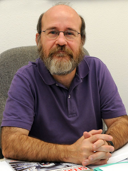
Associate professor of archeology at the University of Murcia. Director of the Museum of the University of Murcia. Dr. in Iberian archaeology. His research has focused on the Iberian World with the thesis: The Iberian cemeteries in Murcia. A paradigmatic example. Coimbra del Barranco Ancho. Analytical study. He is the author of fifteen books and hundreds of scholarly articles on Iberian archaeology, Greek pottery and museum.
CEPOAT tab – Academia.edu – Dialnet
Mr. Emiliano Hernández Carrión

Graduate in History. University of Murcia. Doctoral Course: Urban Life and urbanism in the Mediterranean area. Municipal Archaeologist of the City of Jumilla.
Ms. Rosa Gualda
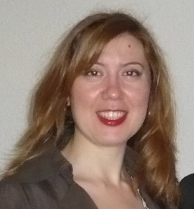
Graduate in Ancient History and Archaeology from the University of Murcia. Master in Applied Archaeology. Masters thesis developed aspects with Iberian feminine symbology .PhD candidate in Archaeology.. Professional archaeologist. She has participated as Technical in this excavations of Coimbra del Barranco Ancho. Her work experience has rooted her into Iberian culture. She has worked in The Archeological Museum of El Cigarralejo, Murcia and Jumilla which has allowed her to participate in this cultural period and to take part in diverse investigative projects of scientific investigation and divulgation.
Mr. José Javier Martínez García

Graduate in Ancient History and Archaeology in the University of Murcia. Graduate in Anthropology in Catholic University of Murcia. Doctoral Course: Urban Life and urbanism in the Mediterranean area, Master in Science in GIS, Master in Applied Archaeology, Master Teacher Education and Master in Egyptology.
He has participated as Technical Director in several excavations of urgency and is currently involved in various international projects like Oxyrhynchus (Egypt) or Heracleópolis Magna (Egypt), Julia Valentia (Morocco) Modular Project and national project as Carteia, Baelo Claudia, Coimbra del Barrancho Ancho, Roman Bath of Fortuna, Villaricos, Begastri and Mazarrón Phoenician.
CEPOAT tab – Academia.edu – Facebook
Free Time
Sunday is a day off, so all students can do any activity that interests them such as visiting places in the neighborhood at their own cost or simply rest by the pool.
-Jumilla´s castle.

-Archaelogical Museum (Jumilla).

Seminars
Throughout the campaign the archaeologists will prepare training seminars in archeology, methodology, GIS, photogrammetry, drawing of ceramics, materials inventory, etc in rotating groups for classes with groups of up to 5 people.
All the information will be arranged for students to download from our Virtual Classroom before, during and after training.
Seminars and workshops:
– Introduction to topography.

– Introduction to drawing in Field
– Introduction to Kite Aerial Photography – KAP
 |
 |
-Introduction to stratigraphy with Harris Matrix methodology.

– Introduction to drawing materials

– Introduction to inventory in Data Base software.

– Introduction to GIS with software QGIS.

– Introduction to CAD with software Draftsight
– Introduction to Photogrammetry.


